Google Maps suggests that it is a four-hour drive to Winnipeg from the Canadian border at International Falls. But that is the quickest route - we were going to be following the scenic route which is a bit over five hours. Of course, we also made a few stops along the way!

It's an easy visit with the Customs Officers when entering Canada from International Falls. A very friendly officer, after hearing that we wanted to take the scenic route to Winnipeg directed us through Fort Frances and toward highway 71


After clearing customs, we took Ontario highway 71 north from the border headed for the town of Kenora which lies on the Trans-Canada highway.
This 250-mile drive provides quite a lesson in geography and geology. The route took us through a variety of agricultural and wilderness lands as we left behind the farmland of southern Ontario and continued over the massive area known as the Canadian Shield (Minnesotans know it as the Laurentian Shield) and then back into the rich soil of the grassland plains area of Manitoba.

The initial fifty miles or so of the highway traveling north passes through farmland with a variety of grain and grass under cultivation.


Near Nestor Falls, the character of the area changes dramatically with a multitude of lakes amid shallow soil suitable only for pine and pulpwood forests. At this point, there are a number of "fly-in" fishing services with float-planes based on the large lakes.


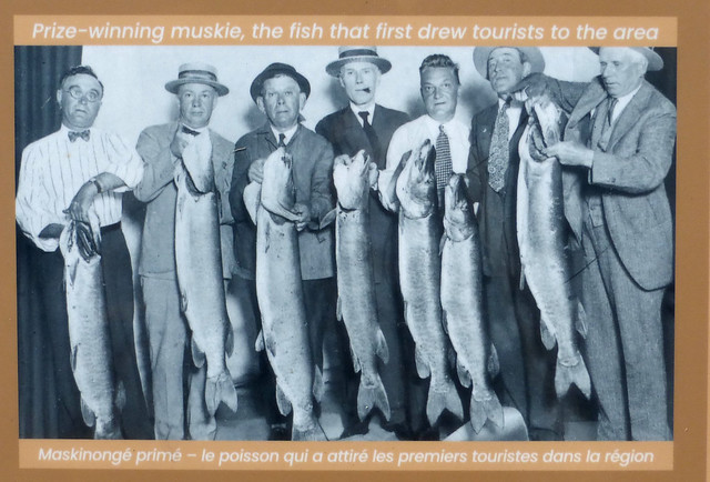
Nestor Falls itself is worth a stop and the sign posted near the falls celebrate the days when fishermen could catch remarkable Muskies and Northerns without flying in deeper into the north woods.


Highway 71 from the border to Kenora is also known as the Heenan Highway, named after a noted Canadian politician who is known as the "father of Canada's Social Security system." I photographed two of the sadly declining quality signs memorializing Keenan's career but while preparing this post, was lucky to find a much higher quality version preserved at Historic Marker Database.


There are numerous names along the way reminding the visitor of Canada's "First Nations" heritage in this area, a name given to the majority of Indigenous Peoples.

The last few miles before reaching Kenora are on the Trans Canada road - in this area it is still mostly a two or three lane highway.

Kenora is a city of about 15,000 population. We headed downtown to McLeod Park where we had been told there was a large statue of "Husky the Muskie."


Husky is indeed a tall fish, worthy of a stop. He also stands amid some lovely beds of flowers and alongside a city lake featuring a large fountain. The fountain was donated by the local Rotary Club and the "Goodwill Geyser" features the most complete description of a fountain nozzle that I can recall, "tapering from 20.32cm to 6.35cm." Also note the float-planes on the far shore of the lake in the view of downtown Kenora.


A few miles west of Kenora, we crossed the border between Ontario and Manitoba and stopped at the visitor information and welcome center for travel suggestions.


A friendly staff at the center suggested we move off the Trans Canada route and pass a few miles farther north near Caddy Lake, along Canada 44, winding through the Canadian Shield countryside. This proved to be a helpful suggestion as we saw a good deal of lakeside scenery and many, many summer cottages by the lakes.

Not far from the visitor's center, lies West Hawk Lake, the deepest lake in Manitoba - almost 400 feet deep. The lake is round in shape, about two miles across, having been formed by a meteor impact in the surrounding granite about 350 million years ago.

We paused a few miles farther along Canada 44 to inspect Lily lake, home to lily pads and frogs.


The meandering path of Canada 44 provided a slow, but scenic, drive through a wilderness portion of the Canadian Shield until we broke out once again into the agricultural land about halfway west to Winnipeg at Siegs Corner. The attractive town of Beausejour looks like it would be an interesting stop but we were now approaching sunset - perhaps next time?
It was turning dark and rainy as we approached the city of Winnipeg - a modern metropolis of about 750,000. (Photo taken in the light of the next day)

More photos available at this Flickr Photo Album, of course.


No comments:
Post a Comment